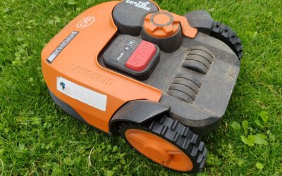
A LiDAR robot lawn mower works by firing rapid laser pulses in a 360-degree circle around itself, measuring the time each pulse takes to bounce back from objects like trees, fences, and house walls. Those measurements create a real-time point cloud that the mower uses to build a precise 3D map of your yard. Once the initial map is stored, the mower can track its own position on that map by constantly comparing new laser readings to the saved data, letting it navigate your lawn without ever needing a buried boundary wire. This laser-based navigation is the core reason wire free robot mowers have become practical in recent years.
Pros
- No perimeter wires required, saving installation time and avoiding tripping hazards.
- Integrated edge trimmer eliminates the need for a separate trimmer for lawn borders.
- Advanced obstacle avoidance keeps the mower safe around people and pets.
- Fast recharge and automatic resume means minimal downtime.
- Accurate mapping works in low light and under trees.
Cons
- High upfront cost compared to wire-based robotic mowers.
- Requires a stable Wi-Fi connection for app features and firmware updates.
- May struggle with very steep slopes or extremely uneven terrain (not specified but typical for such mowers).
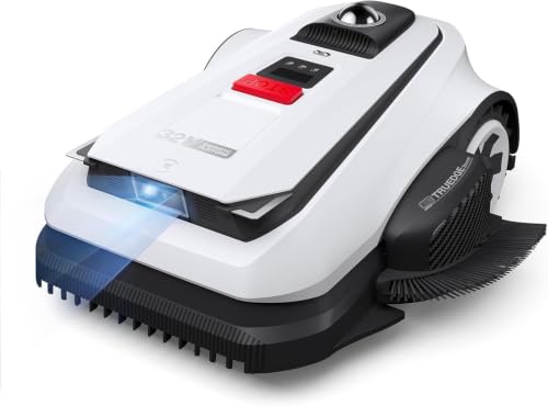
The ECOVACS Goat A2000 LiDAR PRO is a high-end robotic lawn mower designed for homeowners with medium-sized lawns up to half an acre. It stands out by eliminating the need for perimeter wires, using dual-LiDAR technology to map and navigate your yard autonomously. This mower is ideal for those who want a premium, hands-free mowing experience with minimal setup.
Its dual-LiDAR navigation system, called HoloScope 360, combines a rotating LiDAR with 3D-ToF LiDAR for precise positioning even under trees or at night. The built-in TruEdge string trimmer automatically cuts along borders, reducing manual trimming. The dual-blade cutting system with a 13-inch path handles thick grass efficiently, and the cutting height adjusts electronically via the app.
The mower has a robust white plastic body with dimensions of 30x17x23 inches. It features AIVI 3D obstacle avoidance that recognizes over 200 objects, ensuring safe operation around pets and children. The 32V battery system recharges in about 50 minutes, and the mower resumes unfinished tasks automatically, minimizing downtime.
The main drawback is the price, which is significantly higher than many wire-based competitors. Additionally, the mower relies on a strong Wi-Fi connection for full functionality, which could be an issue in remote areas. The lack of published reviews means long-term reliability is unverified, though ECOVACS is a known brand in robotics.
Overall, the ECOVACS Goat A2000 LiDAR PRO offers cutting-edge navigation and trimming features that justify its premium price for tech-savvy lawn owners. If you want a wire-free, intelligent mower that can handle complex yards with minimal intervention, this is a strong contender. However, budget-conscious buyers may want to consider alternatives.

Pros
- Powerful 4WD climbs steep hills up to 80% gradient without slipping
- Advanced LiDAR + AI navigation maintains stable signal near obstacles, no boundary wires needed
- Fast cutting with dual discs and Rush mode covers large areas quickly
- Excellent obstacle handling with suspension and zero-turn capability
- Smart security features include GPS tracking and 24/7 monitoring
Cons
- High upfront cost compared to entry-level robotic mowers
- Requires Wi-Fi and cellular (4G) for full smart features and tracking, which may have ongoing costs
- Maximum lawn size of 0.62 acre may not suit larger properties
The Dreame A3 AWD Pro 2500 is a premium robotic lawn mower designed for homeowners with complex, uneven yards. It uses a combination of 360-degree LiDAR and binocular AI vision to navigate without boundary wires, making setup simple and flexible. This mower is best suited for those who want a hands-off solution on slopes, multi-zone lawns, or properties with many obstacles like trees and flower beds.
Standout features include true four-wheel drive that climbs slopes up to 38.7 degrees and a suspension system that rolls over roots and curbs up to 2.2 inches high. The OmniSense 3.0 navigation system avoids over 300 obstacles in real time, and the dual floating cutting discs provide a 15.8-inch cutting width. With Rush mode it can mow up to 8611 square feet per hour, while EdgeMaster 2.0 trims close to borders for a professional finish.
Build quality is robust with heavy-duty off-road wheels and a weight of 26.4 pounds, giving it stability on wet grass and uneven ground. The design is a medium gray and measures about 39 by 17 by 23 inches. The Dreamehome App allows one-tap height adjustment between 1 and 4 inches, and you can set schedules, create no-go zones, and manage up to 100 zones. Security features like GPS and 4G tracking add peace of mind if the mower is moved.
Potential drawbacks include a high price point and the need for a cellular connection to use tracking and real-time alerts, which might incur extra fees. The 0.62 acre limit may not be enough for larger lawns, and there are no customer reviews yet to confirm real-world durability. Additionally, users who prefer a completely silent mower during operation will appreciate its ultra-quiet performance, but those with tall, dense grass over 8 inches may need to pre-cut.
Overall, the Dreame A3 AWD Pro 2500 is a top-tier choice for tech-savvy homeowners who want a wire-free, reliable mower that handles steep terrain and complex layouts. Its smart navigation and obstacle avoidance are best-in-class, though the investment is significant. If you value convenience and have a smaller, challenging yard, this mower delivers exceptional hands-free lawn care.

Pros
- Exceptional traction on steep slopes and uneven terrain
- Wire-free setup with accurate LiDAR navigation
- Fast recharge time (45 minutes)
- Whisper-quiet operation suitable for any time of day
- Smart features including app control and security camera
Cons
- Higher upfront cost compared to basic robot mowers
- Optional trimmer module sold separately for tighter edges
- Coverage limited to 0.5 acre without additional units
The DREAME A3 AWD is a high-end robotic lawn mower that combines powerful all-wheel drive with advanced LiDAR and AI vision. It is designed for homeowners with challenging lawns featuring steep slopes, complex shapes, and obstacles. Unlike traditional mowers that require buried boundary wires, the A3 AWD maps your yard in minutes using 360-degree LiDAR and binocular AI, ensuring precise navigation even under heavy tree cover.
Standout features include its ability to handle slopes up to 80% and climb over obstacles up to 2.17 inches. This makes it suitable for properties with rolling hills or multi-level terrains. The 45-minute fast charge is a significant advantage, reducing downtime and allowing the mower to complete up to half an acre in a single day. Additionally, the ultra-quiet operation means you can schedule mowing at night without disturbing the peace.
Build quality is robust with a 26.4-pound chassis designed for durability. The included 4G module and HDR camera provide real-time monitoring and theft protection, adding security value. The Dreamehome app offers intuitive control, including custom mowing patterns and animal-friendly modes. However, the optional trimmer module is sold separately, which may be a minor inconvenience for those wanting the smallest possible edge gap.
One potential drawback is the price point, which is higher than many entry-level robot mowers. However, considering the advanced features and the elimination of monthly lawn care bills, it can be a cost-effective long-term investment. Also, the coverage area is rated up to 0.5 acre, so larger properties may need additional units.
Overall, the DREAME A3 AWD is an excellent choice for tech-savvy homeowners who prioritize a wire-free, high-performance mowing solution. It delivers professional-grade results with minimal effort, making weekends truly free for relaxation. If you have a challenging lawn and want top-tier technology, this mower is worth the investment.
Pros
- Effortless slope handling with all-wheel drive on inclines up to 80%
- Wire-free setup and reliable LiDAR navigation under dense tree cover
- Fast 45-minute recharge saves time and covers larger lawns efficiently
- Quiet enough for nighttime use, keeping your yard pristine daily
- Smart app control with real-time camera monitoring and theft deterrent
Cons
- Premium price point may be steep for budget-conscious buyers
- No customer reviews yet, so real-world performance is unverified
- Edge trimming module sold separately for the tightest cut
The Dreame A3 AWD 2000 LiDAR Robot Lawn Mower is a top-tier solution for homeowners tired of manual mowing on challenging terrain. With its all-wheel drive and robust hub motors, it conquers slopes up to 80% and rolls over obstacles like garden hoses and toys. This mower is designed for those with complex, multi-zone lawns who demand professional results without the hassle of buried wire or monthly service fees.
Outstanding features include a 360-degree LiDAR and binocular AI vision system that maps your yard in minutes and follows a path accurate to under 2 inches from edges. The optional trimmer module (sold separately) shrinks that gap to under 1.18 inches, approaching weed-whacker precision. The 45-minute fast charge is a game-changer: a 5A adapter refills the battery 22% faster than competitors, allowing the mower to cover up to half an acre in a single day.
Build quality is solid with a gray, weather-resistant body measuring 25 x 17 x 11.6 inches and weighing 26.4 pounds. The ultra-quiet operation means you can schedule mowing at night without disturbing sleep or neighbors. The Dreamehome app gives you full control, including real-time monitoring via an HDR camera and a built-in 4G module for theft protection. It avoids over 300 objects, including pets and kids' toys.
Potential drawbacks: the price is high for an entry-level robot mower, and as a newly released product, there are no customer reviews yet to confirm long-term reliability. The coverage tops out at 0.5 acre, so owners of larger properties may need a second unit. The edge-trimming module is an extra cost if you desire the tightest cut.
Overall, the Dreame A3 AWD is an excellent investment for homeowners with steep, irregular lawns who want a hands-free, premium mowing experience. It delivers on its promises of wire-free setup, steep slope climbing, and fast charging. If you value weekends free from lawn work and are willing to invest upfront, this mower is a top contender in the robotic lawn mower market.
Color: Gray
Dimensions: 25 x 17.05 x 11.57 inches
Weight: 26.4 pounds
Product Group: Lawn & Patio
Battery Charge Time: 45 minutes (with 5A adapter)
Coverage Capacity: 0.25 to 0.50 acre
Slope Grade: Up to 80% (38.7 degrees)
Obstacle Climb: Up to 2.17 inches
Navigation: 360-degree LiDAR + Binocular AI Vision
Connectivity: 4G module, HDR camera, Dreamehome App
Pros
- No perimeter wire installation required, saving time and effort.
- Precise edge trimming integrated into the mower, reducing manual touch-ups.
- Excellent obstacle detection and avoidance, protecting pets and property.
- Works well in shaded or GPS-denied areas like under trees.
- Compact design fits through narrow gates and tight corridors.
Cons
- May still require occasional manual trimming for complex corners or raised edges.
- Initial app setup and zone customization may need a few adjustments for optimal performance.
- Currently no user reviews available to validate long-term reliability.
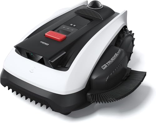
The ECOVACS Goat O1000 LiDAR PRO is a wire-free robotic lawn mower that leverages a dual-LiDAR navigation system to map and mow lawns up to 1/4 acre without the need for perimeter wires. It is designed for homeowners who want a hands-off mowing experience, especially those with complex yard layouts, shaded areas, or narrow paths that challenge traditional robotic mowers.
Its standout feature is the HoloScope 360° Dual-LiDAR system, which provides wire-free mapping and precise 2 cm positioning even under trees or near fences. The integrated TruEdge trimmer allows the mower to cut along borders, reducing the need for manual string trimming. The advanced AI obstacle detection identifies over 200 types of objects, ensuring safe operation around toys, pets, and garden furniture.
The mower has a narrow body design, measuring just 0.8 m wide, enabling it to pass through tight spaces where larger mowers get stuck. The build quality feels solid, with a white finish that blends into most outdoor environments. The app control is intuitive, offering customizable mowing zones, schedules, and no-go areas, though initial setup may require some fine-tuning.
While the mower handles most edge trimming, highly complex corners or raised edges may still need occasional manual trimming. The app setup can have a learning curve, and as a new product, there are no long-term user reviews yet to gauge reliability. Additionally, the price point is premium, but it reflects the advanced wire-free technology and AI capabilities.
Overall, the ECOVACS Goat O1000 LiDAR PRO is a compelling choice for homeowners seeking a wire-free, intelligent lawn mower that excels in obstacle avoidance and edge trimming. Its LiDAR navigation sets it apart from GPS-based alternatives, especially in shaded yards. If you value convenience and have a complex lawn, this mower is worth considering.
How LiDAR Technology Works in a Robot Mower
LiDAR stands for Light Detection and Ranging. The mower mounts a small spinning laser module on top of its chassis, often inside a protective turret. As the laser rotates, it emits thousands of pulses per second in every direction. Each pulse hits a surface and reflects back to a sensor on the mower.
The mower calculates the distance to that surface by multiplying the travel time of the pulse by the speed of light and then dividing by two. Repeating this process for every direction builds a dense cloud of points that describes the shape of your yard and all the objects in it. The result is a highly accurate digital twin of the lawn.
How a LiDAR Mower Maps Your Lawn
During the first run, a LiDAR mower typically does a systematic sweep of the entire yard. It may use a bump sensor or edge detection to feel along fences and flowerbeds while the laser simultaneously records the geometry of those boundaries. The mower stores all the captured points in onboard memory.
You can often watch this initial mapping process in a companion app, where a wireframe of your yard appears and fills in as the mower moves. Once the map is complete, the mower uses it to plan efficient cutting paths and to know exactly where the lawn ends and the flower bed begins. The map can be edited in the app if you later add a garden bed or change a fence line.
How the Mower Navigates and Avoids Obstacles
While mowing, the LiDAR sensor continuously scans the environment, even as the mower moves. The onboard computer runs a simultaneous localization and mapping algorithm, commonly called SLAM. SLAM compares each new laser frame to the stored map to determine exactly where the mower is at that moment.
If a childs toy, a pet, or a fallen branch appears in the mowers path, the laser scan detects the new object instantly. The mower slows down, stops, or drives around it, then resumes its pattern. Because LiDAR works with light, not visible light wavelength cameras, it functions equally well in direct sunlight and complete darkness.
Advantages of LiDAR Over Traditional Boundary Wires
The biggest advantage of LiDAR navigation is the elimination of buried boundary wire. You do not have to dig trenches, staple wire around flower beds, or repair breaks caused by digging animals or garden tools. The mower recognizes your lawns shape from its map alone.
LiDAR also allows the mower to handle complex yard shapes with multiple islands, narrow passages, and irregular borders more gracefully than wire based systems. The map gives the mower full awareness of where it can and cannot go without needing physical markers.
Limitations and Situations Where LiDAR May Struggle
LiDAR works best when the laser beam can reflect cleanly off objects. Very tall or extremely wet grass, thick brush overhanging the mower deck, and highly reflective surfaces like large windows or metal fences can confuse the sensor. In those cases, the mower may misframe the edge of the lawn or fail to detect a low obstacle.
Dust and heavy fog also reduce laser range, though most residential mowers operate at short distances where this is rarely a problem. The main practical limitation is that the spinning laser module protrudes above the mower, which can get stuck under low hanging branches or deck overhangs. Keeping the mower path clear of low obstructions solves this issue.
What to Consider When Using a LiDAR Mower
- Make sure the initial map is captured on a clear day when the grass is dry and not too long. Wet or overgrown conditions can cause incomplete scans.
- Trim any branches or shrubs that hang lower than the LiDAR turret height to prevent the mower from getting stuck.
- If your yard has large reflective surfaces like a pool or sliding glass doors, confirm that the mower can be set to ignore those areas in the app.
- Plan for the mower to need two or three mapping runs to refine its map before it mows efficiently.
Once you have a clean map, your LiDAR mower will follow it faithfully season after season. If you want a step by step walkthrough of the mapping process for a wire free mower, check out our guide on how to map a wire free robot mower, which details exactly what to expect from the first setup through the final cut.
Frequently Asked Questions
Does LiDAR work in the dark?
Yes. LiDAR uses its own laser pulses, so it does not depend on ambient light. The mower can navigate and mow at night or in heavy shade just as accurately as it does in bright sunlight.
Can a LiDAR mower handle slopes?
LiDAR itself handles slopes fine because it measures distance regardless of tilt. However, the mowers wheel traction and maximum incline rating are separate factors. Most LiDAR mowers have a slope limit of around 15 to 25 degrees, depending on the model.
Does LiDAR need a clear line of sight to every object?
The laser requires a direct path to an object to measure it. Objects hidden behind other objects, such as a small flower pot behind a bush, will not be detected until the mower moves to a position with a clear view. The mower uses its memory of the map to compensate.
How is LiDAR different from RTK GPS on a robot mower?
LiDAR builds a map from laser reflections and does not need a satellite signal, so it works in covered yards and near tall buildings. RTK GPS uses satellite corrections and a base station or cellular correction signal, which can be blocked by dense tree cover. LiDAR typically offers finer obstacle detection, while RTK often handles very large lawns better.
Do LiDAR mowers require Wi Fi to work?
No. The LiDAR mapping and navigation are processed entirely onboard the mower. Wi Fi is only needed if you want to use the mobile app to view the map, adjust schedules, or receive notifications. The mower can operate independently without an internet connection.
Related Guides
Final Thoughts on LiDAR Robot Lawn Mowers
LiDAR robot lawn mowers work by using laser pulses to build a 3D map of your yard, letting them navigate and mow without boundary wires. If you are comparing navigation technologies, you might also want to understand how GPS based mowers work. Read our article on how does GPS robot lawn mower work to see which approach fits your lawn best.