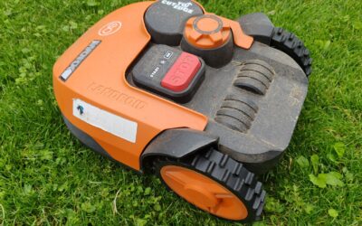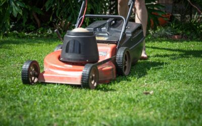
A LiDAR robot lawn mower uses laser pulses to scan and map your yard in real time, creating a detailed 3D picture of obstacles, terrain, and boundaries without needing a buried wire. The mower emits light beams that bounce off objects and return to the sensor, which calculates distance and position to build a navigation map. This technology allows the mower to move efficiently around trees, garden beds, and other obstacles while maintaining accurate path coverage.
Pros
- No perimeter wires required, saving installation time and avoiding tripping hazards.
- Integrated edge trimmer eliminates the need for a separate trimmer for lawn borders.
- Advanced obstacle avoidance keeps the mower safe around people and pets.
- Fast recharge and automatic resume means minimal downtime.
- Accurate mapping works in low light and under trees.
Cons
- High upfront cost compared to wire-based robotic mowers.
- Requires a stable Wi-Fi connection for app features and firmware updates.
- May struggle with very steep slopes or extremely uneven terrain (not specified but typical for such mowers).
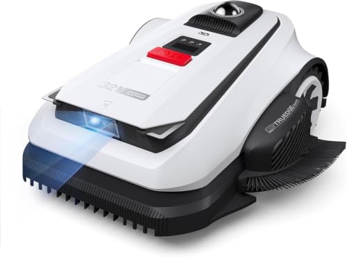
The ECOVACS Goat A2000 LiDAR PRO is a high-end robotic lawn mower designed for homeowners with medium-sized lawns up to half an acre. It stands out by eliminating the need for perimeter wires, using dual-LiDAR technology to map and navigate your yard autonomously. This mower is ideal for those who want a premium, hands-free mowing experience with minimal setup.
Its dual-LiDAR navigation system, called HoloScope 360, combines a rotating LiDAR with 3D-ToF LiDAR for precise positioning even under trees or at night. The built-in TruEdge string trimmer automatically cuts along borders, reducing manual trimming. The dual-blade cutting system with a 13-inch path handles thick grass efficiently, and the cutting height adjusts electronically via the app.
The mower has a robust white plastic body with dimensions of 30x17x23 inches. It features AIVI 3D obstacle avoidance that recognizes over 200 objects, ensuring safe operation around pets and children. The 32V battery system recharges in about 50 minutes, and the mower resumes unfinished tasks automatically, minimizing downtime.
The main drawback is the price, which is significantly higher than many wire-based competitors. Additionally, the mower relies on a strong Wi-Fi connection for full functionality, which could be an issue in remote areas. The lack of published reviews means long-term reliability is unverified, though ECOVACS is a known brand in robotics.
Overall, the ECOVACS Goat A2000 LiDAR PRO offers cutting-edge navigation and trimming features that justify its premium price for tech-savvy lawn owners. If you want a wire-free, intelligent mower that can handle complex yards with minimal intervention, this is a strong contender. However, budget-conscious buyers may want to consider alternatives.

Pros
- Truly wire-free installation saves time and hassle compared to traditional robotic mowers.
- Dual-LiDAR provides reliable navigation in shaded or obstructed areas where GPS fails.
- Edge trimming capability reduces the need for manual edging along walkways and gardens.
- Effective obstacle avoidance protects pets, toys, and garden decorations during operation.
- Compact size allows it to access narrow pathways and complex lawn layouts with ease.
Cons
- Higher upfront cost compared to some wire-based robotic mowers on the market.
- Requires a flat, well-defined lawn area for optimal performance on slopes or uneven terrain.
- Battery life and coverage may vary in very hot or cold weather conditions.
The ECOVACS Goat O1000 LiDAR PRO is a wire-free robotic lawn mower designed for homeowners who want a smarter, easier way to maintain their lawn without the hassle of installing perimeter wires. It is particularly suited for lawns up to 1/4 acre with complex layouts, narrow pathways, or challenging obstacles like trees and garden décor.
Its standout feature is the HoloScope 360 degree Dual-LiDAR Navigation system, which creates a precise map of your yard without needing GPS or RTK antennas. This allows the mower to operate accurately even under dense foliage or near metal fences, areas where many GPS-based mowers struggle. Combined with AI Vision and 3D ToF LiDAR, it detects and avoids over 200 types of obstacles, making it one of the most advanced consumer robotic mowers in terms of safety and navigation.
The built-in TrueEdge border trimming system is another highlight, mowing close to edges like driveways and flower beds to minimize manual touch-ups. The compact, slim body measures 23.6 by 12.0 by 18.9 inches and can navigate passages as narrow as 31.5 inches, making it ideal for side yards and multi-zone lawns. The all-black design is discreet and blends well into most garden environments.
One potential drawback is the price point, which is higher than some wire-based alternatives. Additionally, while the app control offers extensive customization including no-go zones and schedules, the initial setup and mapping process may take a few cycles for perfect results. Battery life is adequate for a quarter-acre lot, but performance in very hot or wet grass may require more frequent charging.
Overall, the ECOVACS Goat O1000 LiDAR PRO delivers on its promise of a truly wire-free, intelligent mowing experience. It is a worthy investment for tech-savvy homeowners who value convenience, precision, and a neatly trimmed lawn without the chore of manual edging. With robust obstacle avoidance and reliable navigation, it sets a new standard for battery-powered robotic mowers in its class.

Pros
- No perimeter wires or complex setup required, saving time and installation costs
- Dual LiDAR and AI vision provide exceptional obstacle detection and route planning
- High mowing efficiency with 32V battery and dual blades, covering large lawns quickly
- Robust slope handling up to 50%, suitable for hilly or uneven terrain
- Waterproof IPX6 design allows easy hose cleaning and outdoor longevity
Cons
- Premium price point may be a barrier for budget-conscious buyers
- No user reviews available yet, so real-world performance is unverified
- At 29 inches wide, it may be too large for very narrow pathways or small lawns
The ECOVACS Goat A3000 is a wire-free robotic lawn mower designed for homeowners with medium to large, complex lawns up to 3/4 acre. It eliminates the need for buried perimeter wires by using dual LiDAR technology to create a precise 3D map of your yard with up to 2cm accuracy. This makes the initial setup fast and hassle-free, and the mower can intelligently navigate around trees, buildings, and other obstacles without manual intervention.
Its standout feature is the combination of dual LiDAR and AI vision, which allows it to recognize and avoid over 200 common garden obstacles including pets, toys, and furniture. In real-world use, this means fewer interruptions and safer operation, even in yards with frequent activity. The powerful 32V battery platform and dual cutting discs deliver an impressive mowing efficiency of up to 400 square meters per hour, leaving a clean, carpet-like finish on your lawn.
The build quality is robust, with an IPX6 waterproof rating that allows for convenient cleaning with a garden hose. The mower also handles challenging terrain well, climbing slopes up to 50% (27 degrees) and crossing small barriers. The smart mapping and multi-area management features let you set schedules and control the mower via the app, making lawn care truly hands-free.
Potential drawbacks include the high price tag, which may not suit all budgets, and the fact that there are no user reviews available yet to confirm long-term reliability. Additionally, its wide 29-inch body might be less ideal for very narrow pathways or small lawns. However, for those with larger, complex yards who want a premium, wire-free solution, these cons are minor.
Overall, the ECOVACS Goat A3000 is an excellent choice for tech-savvy homeowners seeking a high-performance robotic mower with advanced navigation and obstacle avoidance. It offers convenience, efficiency, and durability, making it a strong contender in the premium robotic mower market.
Product Dimensions: 29.13 x 11.73 x 21.26 inches
Color: White
Power Platform: 32V battery system
Cutting Width: 13 inches
Mowing Efficiency: Up to 400 m²/h
Maximum Lawn Size: 3/4 acre (about 3,000 m²)
Navigation: Dual LiDAR with AI vision
Obstacle Detection: Over 200 object types
Slope Capability: Up to 50% (27 degrees)
Waterproof Rating: IPX6
Setup: Wire-free, no perimeter wires needed
App Control: Smart mapping, scheduling, multi-area management
Pros
- No perimeter wire installation required, saving time and effort.
- Precise edge trimming integrated into the mower, reducing manual touch-ups.
- Excellent obstacle detection and avoidance, protecting pets and property.
- Works well in shaded or GPS-denied areas like under trees.
- Compact design fits through narrow gates and tight corridors.
Cons
- May still require occasional manual trimming for complex corners or raised edges.
- Initial app setup and zone customization may need a few adjustments for optimal performance.
- Currently no user reviews available to validate long-term reliability.
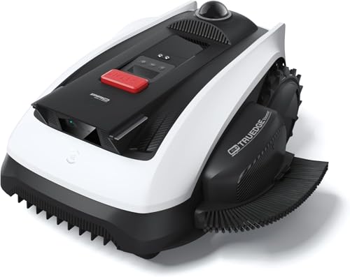
The ECOVACS Goat O1000 LiDAR PRO is a wire-free robotic lawn mower that leverages a dual-LiDAR navigation system to map and mow lawns up to 1/4 acre without the need for perimeter wires. It is designed for homeowners who want a hands-off mowing experience, especially those with complex yard layouts, shaded areas, or narrow paths that challenge traditional robotic mowers.
Its standout feature is the HoloScope 360° Dual-LiDAR system, which provides wire-free mapping and precise 2 cm positioning even under trees or near fences. The integrated TruEdge trimmer allows the mower to cut along borders, reducing the need for manual string trimming. The advanced AI obstacle detection identifies over 200 types of objects, ensuring safe operation around toys, pets, and garden furniture.
The mower has a narrow body design, measuring just 0.8 m wide, enabling it to pass through tight spaces where larger mowers get stuck. The build quality feels solid, with a white finish that blends into most outdoor environments. The app control is intuitive, offering customizable mowing zones, schedules, and no-go areas, though initial setup may require some fine-tuning.
While the mower handles most edge trimming, highly complex corners or raised edges may still need occasional manual trimming. The app setup can have a learning curve, and as a new product, there are no long-term user reviews yet to gauge reliability. Additionally, the price point is premium, but it reflects the advanced wire-free technology and AI capabilities.
Overall, the ECOVACS Goat O1000 LiDAR PRO is a compelling choice for homeowners seeking a wire-free, intelligent lawn mower that excels in obstacle avoidance and edge trimming. Its LiDAR navigation sets it apart from GPS-based alternatives, especially in shaded yards. If you value convenience and have a complex lawn, this mower is worth considering.

How LiDAR Scanning Works
LiDAR stands for Light Detection and Ranging. The sensor mounted on top of the mower sends out laser pulses in a rotating pattern, scanning the area around it hundreds of times per second. Each pulse that reflects back provides information about what’s nearby and how far away it is.
The mower’s onboard computer processes this continuous stream of data to build a live map of your yard. Unlike a camera that needs good lighting, LiDAR works equally well in bright sun or cloudy conditions, and it doesn’t rely on recognizing visual patterns. This makes it a reliable choice for consistent navigation regardless of time of day.
Wire-Free Navigation Without Boundary Installation
Traditional robot mowers require you to bury a perimeter wire around your lawn to define the cutting area. LiDAR eliminates this step entirely by using its laser map to understand where your yard ends and obstacles begin. You can place the mower down and let it learn your yard’s layout on its own.
This convenience comes with a trade-off: setup takes longer because the mower must complete several passes to build an accurate map of your property. Once mapped, however, the mower can operate independently without ongoing boundary maintenance. If your yard layout changes, the mower can adapt to new obstacles on the fly.
Obstacle Detection and Avoidance
LiDAR’s real-time scanning means the mower detects obstacles as it moves, not just at startup. If a child’s toy, garden hose, or branch falls into the yard during mowing, the sensor recognizes it and steers around it. This active detection prevents collisions and reduces the need for you to clear the yard beforehand.
The laser can sense objects at varying heights, from ground level to several feet up. This allows the mower to navigate under low tree branches while still detecting a low fence or raised garden bed that might block its path.
Comparison to GPS and Boundary Wire Systems
LiDAR differs from GPS-based navigation, which relies on satellite signals to determine the mower’s location. GPS systems work best on large, open properties and can struggle under dense tree cover. LiDAR works equally well in any yard size and doesn’t depend on signal quality or weather.
Unlike older boundary wire systems, LiDAR doesn’t require you to dig a trench or maintain buried cables. However, some modern mowers still offer the option to use boundary wire alongside LiDAR for added precision control in specific areas of your yard.
Precision and Mapping Accuracy
LiDAR provides centimeter-level accuracy in mapping, meaning the mower knows its exact position within a few centimeters. This precision allows for efficient mowing patterns that minimize missed strips and overlapping coverage. The mower can create organized, parallel cutting lines rather than random paths.
Over time, the mower refines its map with each mowing session. It learns the exact shape and features of your yard, which improves navigation efficiency and coverage consistency as the season progresses.
Terrain Handling and Slope Navigation
LiDAR sensors detect changes in ground elevation, which helps the mower navigate slopes and uneven terrain more intelligently. By understanding the terrain’s contours, the mower can adjust its path to avoid getting stuck or tipping on steep sections. This is especially useful on yards with hills or significant grade changes.
The technology doesn’t solve all terrain challenges, though. A mower still needs adequate wheel traction and motor power to handle steep slopes, but LiDAR helps it make smarter decisions about which routes are safest.
What to Know Before Choosing a LiDAR Mower
- Allow extra time for initial setup so the mower can complete its first mapping passes.
- Clear your yard of large debris before the first mowing to help the mower build an accurate map.
- Position the charging dock in an open area where the mower can easily return and dock without obstruction.
- Understand that LiDAR works in any lighting condition, so you can mow at dawn, dusk, or even on cloudy days.
- Check whether the mower offers app-based controls to monitor mapping progress and adjust no-mow zones if needed.
If you’re considering a LiDAR mower for challenging terrain, comparing models designed specifically for bumpy lawns and uneven terrain can help you find one with the right balance of LiDAR precision and physical capability for your property.
Frequently Asked Questions
Does LiDAR work in rain or heavy cloud cover?
Yes, LiDAR operates independently of weather and lighting conditions. Rain and clouds don’t interfere with laser scanning the way they would with GPS or camera-based systems. The mower can mow during overcast days or light rain without losing navigation accuracy.
Can LiDAR detect small objects like toys or sticks?
LiDAR can detect most small objects, but detection depends on the object’s size and reflectivity. A plastic toy or a stick will typically be detected and avoided. Very small or low-profile items might occasionally be missed, so it’s still good practice to scan your yard before mowing.
How long does it take for a LiDAR mower to map a yard?
Initial mapping usually takes 1-3 mowing sessions depending on yard size and complexity. After the first complete map is created, the mower can operate normally on subsequent sessions. It continues to refine its map with each pass, improving efficiency over time.
Is LiDAR more accurate than GPS navigation?
LiDAR offers better accuracy in small to medium yards and works reliably under tree cover where GPS signals weaken. GPS excels on large, open properties with clear sky access. Many modern mowers combine both technologies for optimal performance in varied conditions.
Do I still need a boundary wire if my mower has LiDAR?
No, LiDAR eliminates the need for boundary wire in most cases. However, some users add optional boundary wire to define specific no-mow zones or to add an extra layer of containment for peace of mind on properties near roads or water features.
Related Guides
- How Does LiDAR Robot Lawn Mower Work
- How Accurate Is LiDAR Robot Mower?
- Sunseeker X5 Cyber Monday Deals
- ANTHBOT Robot Mower Cyber Monday Deals
Conclusion
LiDAR robot lawn mower technology uses laser scanning to navigate and map your yard without buried wires or satellite signals, offering reliable operation in any weather or lighting condition. Understanding how this technology works helps you decide whether it’s the right choice for your lawn and property layout.